銀座公式ウェブサイト
Explore Ginza
Announcements ・ Updates
More about Ginza
Visit Shrines
Vol.3 Exploring Ginza in the Edo Period on an old map
2020.08.01
In this volume, instead of visiting a shrine we will explore the history of Ginza in the Edo period using old maps.
- Ogikubo
- Which Inari shrine are we going to visit this time?
- Uino
- I wish I could invite you on another tour today,
but I am afraid we are not going anywhere this time. - Ogikubo
- That’s too bad.
- Uino
- I’m sorry. The year 2020 will be remembered in history.
The COVID-19 pandemic drove the entire city of Tokyo to stay home. This has been an unprecedented experience. - Ogikubo
- I have not been to Ginza since the State of Emergency Declaration was made in April. What was it like?
- Uino
- It was an incredible sight. Busy Ginza had not a person in the streets! It was impressive how all local stores and facilities, big and small, closed all at once.
Only Ginza could so gracefully suspend business activities to prevent the spread of infections. - Ogikubo
- With the lifting of the State of Emergency Declaration, more people are going into town; and thus the number of infected people are on the increase. I am more reluctant to visit Ginza just for a stroll.
- Uino
- That is why we are not going to actually visit a shrine today, and are instead going to travel back in history to visit Ginza in the past through images on the computer.
You have guided many town walks. Have you ever written about Ginza? - Ogikubo
- Actually, I have never been to Ginza on a town walk. I used to ride my bike all over Tokyo, and I wrote my first guide book, Tokyo Kodo Sanpo (Walking Tokyo’s old roads) after I realized how interesting it was to go through old streets that have been around for ages. Back then, I was exploring streets that were built before the Edo period so I never got to Ginza. /dd>
- Uino
- That means Ginza’s history only goes back to the Edo period?
- Ogikubo
- That’s right. Before the Edo period, the Ginza area faced the ocean on its east and west. The area from Nihonbashi to Shinbashi, with Chuo-dori running through the middle, was located on a peninsula called “Edo Maeshima” stretching out southward.
For example, Hibiya, located to the east of Ginza, was still under the sea. To be more precise, the area from around Shinbashi to Hibiya was called “Hibiya Irie,” or Hibiya Bay. That is a rough description of the area. - Uino
- Really! So, Ginza was on land and Hibiya was under the sea?
- Ogikubo
- That is right. Hibiya was in the ocean, while Ginza was land! It was more like a sandbar peninsula. You could even call it Ginza Peninsula. Ieyasu reclaimed Hibiya Irie and let Tokaido run through what is Ginza today, on firm ground, building a bridge over the channel running through the reclaimed land and a road along the coastline. Shinbashi (literally, “new bridge”) is an old bridge for us, but was given that name because it was new at the time. That is why even today Ginza is located at a slightly higher altitude than surrounding areas.
- Uino
- I am getting lost already…
- Ogikubo
- Then let us lay everything out on a map. Ginza would roughly have looked like this based on various books and geological maps.
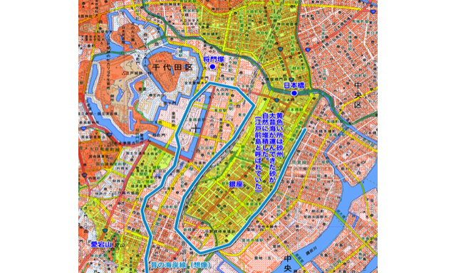
- Uino
- I see. I get the picture now, although it still feels strange. I guess you are not so familiar with what happened afterwards in the Edo period?
- Ogikubo
- Actually, I love collecting old maps and I have been buying affordable maps at used book stores from quite a while back. I do not have many maps from the Meiji period because they are very expensive, but I do have many maps of Tokyo printed during the Taisho period and onwards. When it comes to maps dating back to the Edo period, they are not for common people to purchase, but maps in the possession of the National Library have been digitalized for online viewing. Although I am hopeless at remembering the names of the Shoguns of the Tokugawa family or historical events, it is fascinating to see how the name of each town changed over time. It is quite intriguing to follow the changes in local geography from the Edo period to the Showa period.
- Uino
- The National Library! They have such a large variety of resources that I always find myself deviating from what I had originally wanted to research.
- Ogikubo
- My thoughts exactly. In the National Library archives, I found a map called “Bushu Toshima-gun Edo Sho-zu” According to the description, it is the oldest existing map of Edo and is believed to have been made in Kanei 9.
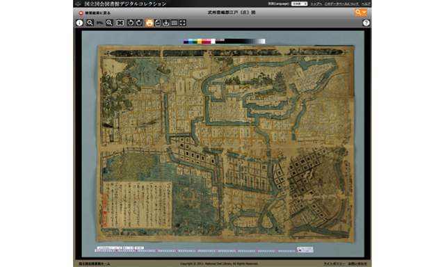
Printed in around 1632
- Uino
- Kanei 9―。The Edo period is so long that I have no clue how far back that is.
- Ogikubo
- I know what you mean. On the Western calendar, the year is 1632. Tokugawa Ieyasu became Shogun in 1603, so it was around thirty years into the Edo period, during the reign of the third Shogun, Tokugawa Iemitsu.
- Uino
- So it is from the very early years of the Edo period, but perhaps just around when Edo was developing into an organized city.
- Ogikubo
- Yes. Let us look closer at the Ginza area on this map. I magnified the area to make it easier to read. Most maps from the Edo period have west oriented towards the top. Likewise, this map points west at the top west and points north on the right.
Printed in around 1632
- Uino
- Modern maps are north-oriented at the top. I am so used to seeing maps that way, so I am getting confused.
- Ogikubo
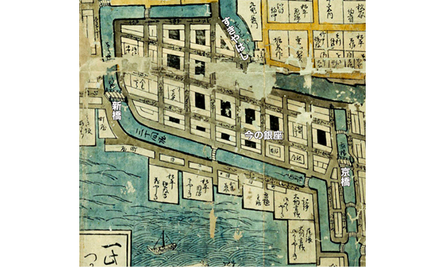
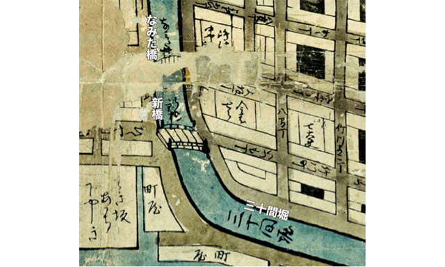
- When you get lost, you should look for a familiar name that remains from these times. For example, on this map you can find “Kyobashi” on the left end and “Shinbashi” on the left end. Can you recognize “Kyobashi?” “Shinbashi” is written in a cursive script but I think you can imagine that it says “Shinbashi” from the shape of the letters. Let us take a closer look at Shinbashi. The great thing about the National Library digital collection is that the material has been digitalized in high resolution so that it can be magnified many times greater.
- Uino
- I can read “Sanjikken-hori.” I recall from our excursion to Asahi Inari Shrine, this is the moat where the spirit rosee. I can tell that that is Shinbashi. Look at that nice little bridge.
- Ogikubo
- Yes. So, Shinbashi was actually built over Sanjikken-bori.
- Uino
- What is that bridge next to Shinbashi?
- Ogikubo
- It says “Namitabashi.”
- Uino
- Ogikubo-san, you are quite good at reading cursive script.
- Ogikubo
- Hmm. I confess I had no confidence in my readings so I searched for other maps of Edo and found one written in Katakana. Some maps have the names of places written out in Kanji and others have them in Katakana or in cursive script. It’s quite complicated. Now let us have a closer look at the area around Kyobashi. Kyobashi is written in letters that even a modern man can identify.
Printed in around 1632
- Uino
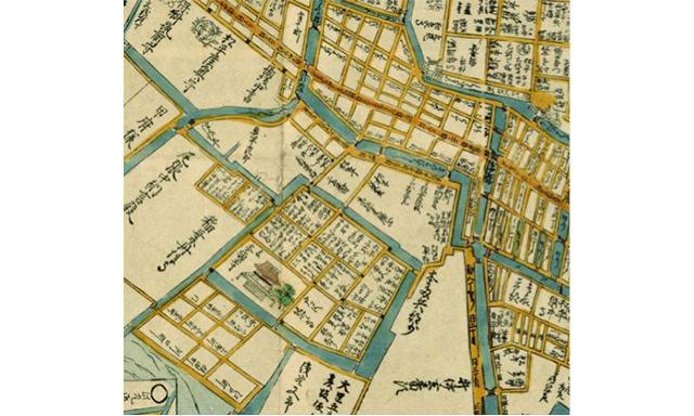
- I found Ginza! This is Ginza, isn’t it?
- Ogikubo
- Yes. The Ginza, or silver mint, was located here, so the area came to be called Ginza. The area around Ginza was home to townsmen (merchants and craftsmen) so each block is named “- cho.” “Cho” can be considered to be the equivalent of “town.”
- Uino
- Maps are very interesting. Hearing geographic history explained in words, I would just nod, but seeing the names mapped out is convincing evidence and allows me to picture the town in detail.
- Ogikubo
- The shogunate had authorized merchants mint silver coins at the silver mint, so Ginza was located in a townsmen area. The silver mint was established in 1612. Later, there was an incident of corruption and it was moved in 1800, but the name Ginza remained.
- Uino
- Corruption! I’m curious to know what happened (laughs). I have heard that when the missionaries came to Japan, we were the world’s leading silver producer. I would guess that a lot of silver coins were minted during the Edo period. I recall seeing a stone monument in Ginza 2-chome that says “Origin of Ginza.” The government silver mint office was built after the original silver mint and the area came to be known as Ginza.
- Ogikujbo
- Let us return to the entire map of Ginza. There are some samurai residences beyond Sanjusangenbori, but you can see that the ocean spreads out on the east side.
- Uino
- I see. Ginza used to face the ocean. I can also see boats drawn on the map.
- Ogikubo
- What is amazing is the next map – a map from 1682. Fifty years later, the ocean has receded. The Tokaido is traced in red, so that would be today’s Chuo-dori. Expanding the land area by reclaiming Tokyo Bay was an activity dating back to these times. You might even say that it is a Tokyo tradition.
- Uino
- Wow! The land area has really been expanded!
By the way, if Ginza takes its name after the silver mint, was there a Kinza (gold mint) as well? - Ogikubo
- Of course.
- Uino
- I wonder why the name didn’t remain.
- Ogikubo
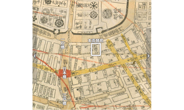
- It does remain. The area around the gold mint used to be called “Honryogaecho.” This is a map from 1772, which is more readable. Nihonbashi is marked in red for some reason, but it was probably marked the owner of the map.
- Uino
- Where is the gold mint on this map?
- Ogikubo
- You can find “Tokiwabashi Gomon” above Nihonbashi, to the right. Tokiwabashi bridge is currently under repair but the stone wall of the Gomon gate remains. Between Tokiwabashi Gomon and Nihonbashi, it says “Honyrokaecho.” This is the gold mint.
- Uino
- Where would that be now?
- Ogikubo
- Well, who controls Japan’s money as did the gold mint back in the Edo period?
- Uino
- The Bank of Japan!
- Ogikubo
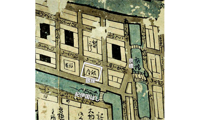
- Yes. The Bank of Japan is located in this area. By the way, I recommend this map, which says “Ginza” in kanji, right where it is located now. Let us look at Ginza on this map.
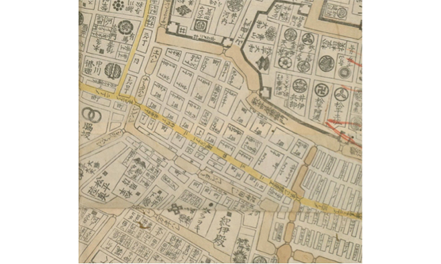
The Tokaido (Chuo-dori, today) is colored in yellow. The basic zoning is the same as today.
- Uino
- According to this map, only current-day Ginza 1-chome to 4 chome was called Ginza. After Ginza 5-chome, the areas are called Owaricho or Takekawacho.
- Ogikubo
- Do you notice the difference between Ginza and its surroundings?
- Uino
- It is surrounded by the residences of rich men!
- Ogikubo
- The area between Kyobashi and Shinbashi, surrounded by channels was the townsmen’s district, which was surrounded by samurai residences. Each residence is marked with the family crest or family name. Aren’t old maps fascinating?
- Uino
- So, building high-end residences on the waterfront isn’t just a modern trend.
Across a city expanding in accordance with population increase, Inari Shrines were built in various locations where both townsmen and samurai came to worship. Although large residences and townhouses have disappeared with the times, these small shrines have survived. I look forward to visiting these small shrines that people have continued to visit carrying different thoughts.
All List
- 2020.05.01 Visit Ginza’s Inari Shrines Vol.2 Asahi Inari Shrine
- 2020.08.01 Vol.3 Exploring Ginza in the Edo Period on an old map
- 2020.11.01 Visit Ginza’s Inari Shrines Vol. 4 Kakugo Inari Shrine
- 2021.02.01 Visit Ginza’s Inari Shrines Vol. 5 Azuma Inari
- 2021.05.01 Visit Ginza’s Inari Shrines Vol.6 Kabuki Inari
- 2021.08.01 Visit Ginza’s Inari Shrines Vol.7 Ginza Inari in Ginza 2-chome
- 2021.11.01 Visiting Ginza’s Shrines Vol. 8 Kumagai Inari Shrine
- 2022.02.01 Visit Ginza Shrines Vol. 9 Saiwai Inari Shrine
- 2022.05.01 Visit Ginza’s Shrine Vol. 10 Mimeguri Shrine and Shusse Jizoson on the roof of Mitsukoshi Department Store
- 2022.08.01 Visit Ginza’s Shrines Vol. 11 Komparu Inari
- 2022.11.01 Visit Ginza’s Inari Shrines Vol.12 Mankin Ryujin Seiko Inari Shrine
- 2023.02.01 Visit Ginza’s Shrines Vol.13 Hachikan Shrine
- 2023.05.01 Visit Ginza’s Inari Shrines Vol.14 Hoju Inari Shrine
- 2023.08.01 Visit Ginza’ Inari Shrines Vol. 15 Ryuko Fudo-son
- 2023.11.01 Visit Ginza’s Shrines Vol. 16 Hodo Inari Shrine
- 2024.02.01 Visit Ginza’s Shrines Vol. 17 Toyoiwa Inari Shrine
- 2024.05.01 Visit Ginza’s Inari Shrines Vol. 18 Yasuhira Shrine
- 2024.08.01 Visit Ginza’s Inari Shrines: Final Edition